**Updated at 9:21 p.m. Friday**
Residents across much of New Brunswick are preparing for the arrival of Hurricane Lee, which forecasters are calling a “large and dangerous” storm.
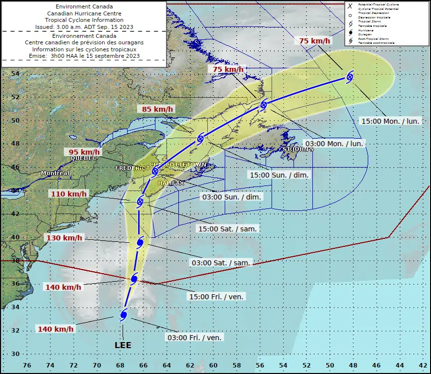
The category-1 hurricane is expected to transition into an intense post-tropical low while making landfall somewhere between Grand Manan and Nova Scotia’s Shelburne County on Saturday evening.
But forecasters say we will start to see the impacts overnight Friday with heavy rain, high winds and large waves.
And the Canadian Hurricane Centre said those impacts will be felt several hundred kilometres away from the storm’s track as the circulation of Lee will be quite broad.
Coastal Charlotte County, including Grand Manan, is under both a hurricane watch and a tropical storm warning.
There is also a tropical storm warning for Saint John and County, Moncton and Southeast New Brunswick, and Fundy National Park. That includes all of the Fundy coast and the Northumberland coast from Tidnish to Shediac.
A tropical storm watch has been issued for central and northeastern New Brunswick, including St. Stephen and Northern Charlotte County, the Kennebecasis Valley, Sussex, Grand Lake, Fredericton, Oromocto, Kent County, Miramichi, Bathurst, and the Acadian Peninsula.
Wind warnings are in place along the Fundy coast and there is a rainfall warning for nearly the entire province.
Hurricane forecasters said the circulation of Lee will be quite broad, so impacts will occur not only near the track but up to 300 kilometres away from it.
Areas under the tropical storm watch will see sustained winds of 70 kilometres per hour with gusts up to 100 kilometres per hour. Those gusts could reach 120 kilometres per hour in areas under the hurricane watch.
For the rest of the province, peak wind gusts are expected to be in the range of 60 to 80 kilometres per hour.
Emergency officials have said those wind speeds could result in tree damage and power outages.
“Widespread power outages appear likely across most of mainland Nova Scotia and near the Fundy Coast of New Brunswick,” the Canadian Hurricane Centre said in its 9 p.m. Friday update.
“Some structural damage to roofing materials and siding, as well as exterior fixtures and fencing are expected.”
Total rainfall amounts will range from 50 millimetres to more than 100 millimetres, particularly through central and northeastern New Brunswick.
High waves and elevated water levels are also forecast along the Fundy coast, but the biggest impact is expected to be along the Atlantic Coast of Nova Scotia.
Wave conditions will also become rough along the east coast of New Brunswick but should remain below warning criteria.
Storm conditions will continue into Saturday evening and ease throughout the night. Sun and clouds are expected to return on Sunday, but gusty winds will stick around.


